


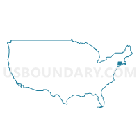
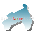
Fairfield, New Canaan, Wilton, Weston & Easton Towns PUMA, Connecticut
About
Outline

Summary
| Unique Area Identifier | 192501 |
| Name | Fairfield, New Canaan, Wilton, Weston & Easton Towns PUMA |
| State | Connecticut |
| Area (square miles) | 130.54 |
| Land Area (square miles) | 126.12 |
| Water Area (square miles) | 4.42 |
| % of Land Area | 96.62 |
| % of Water Area | 3.38 |
| Latitude of the Internal Point | 41.20919960 |
| Longtitude of the Internal Point | -73.36882180 |
Maps

Graphs
Select a template below for downloading or customizing gragh for Fairfield, New Canaan, Wilton, Weston & Easton Towns PUMA, Connecticut


Neighbors
Neighoring Public Use Microdata Area (by Name) Neighboring Public Use Microdata Area on the Map
- Bridgeport Town PUMA, CT
- Danbury, Ridgefield, Bethel, Brookfield, New Fairfield, Redding & Sherman Towns PUMA, CT
- Norwalk, Westport & Darien Towns PUMA, CT
- Stamford & Greenwich Towns PUMA, CT
- Stratford, Shelton, Trumbull, Newtown & Monroe Towns PUMA, CT
- Westchester County (Northeast) PUMA, NY
Top 10 Neighboring County (by Population) Neighboring County on the Map
Top 10 Neighboring County Subdivision (by Population) Neighboring County Subdivision on the Map
- Bridgeport town, Fairfield County, CT (144,229)
- Stamford town, Fairfield County, CT (122,643)
- Norwalk town, Fairfield County, CT (85,603)
- Fairfield town, Fairfield County, CT (59,404)
- Trumbull town, Fairfield County, CT (36,018)
- Newtown town, Fairfield County, CT (27,560)
- Westport town, Fairfield County, CT (26,391)
- Ridgefield town, Fairfield County, CT (24,638)
- Darien town, Fairfield County, CT (20,732)
- New Canaan town, Fairfield County, CT (19,738)
Top 10 Neighboring Place (by Population) Neighboring Place on the Map
- Bridgeport city, CT (144,229)
- Stamford city, CT (122,643)
- Norwalk city, CT (85,603)
- Trumbull CDP, CT (36,018)
- Westport CDP, CT (26,391)
- Darien CDP, CT (20,732)
- Ridgefield CDP, CT (7,645)
- Georgetown CDP, CT (1,805)
- Southport CDP, CT (1,585)
- Wilton Center CDP, CT (732)
Top 10 Neighboring Elementary School District (by Population) Neighboring Elementary School District on the Map
Top 10 Neighboring Secondary School District (by Population) Neighboring Secondary School District on the Map
Top 10 Neighboring Unified School District (by Population) Neighboring Unified School District on the Map
- Bridgeport School District, CT (144,229)
- Stamford School District, CT (122,643)
- Norwalk School District, CT (85,603)
- Fairfield School District, CT (59,404)
- Trumbull School District, CT (36,018)
- Bedford Central School District, NY (28,644)
- Newtown School District, CT (27,560)
- Westport School District, CT (26,391)
- Ridgefield School District, CT (24,638)
- Darien School District, CT (20,732)
Top 10 Neighboring State Legislative District Lower Chamber (by Population) Neighboring State Legislative District Lower Chamber on the Map
- Assembly District 89, NY (129,296)
- State House District 123, CT (24,985)
- State House District 141, CT (24,805)
- State House District 127, CT (24,726)
- State House District 111, CT (24,638)
- State House District 133, CT (24,556)
- State House District 142, CT (24,434)
- State House District 129, CT (24,361)
- State House District 132, CT (24,317)
- State House District 136, CT (24,123)
Top 10 Neighboring State Legislative District Upper Chamber (by Population) Neighboring State Legislative District Upper Chamber on the Map
- State Senate District 40, NY (316,324)
- State Senate District 28, CT (103,194)
- State Senate District 26, CT (102,047)
- State Senate District 22, CT (101,713)
- State Senate District 25, CT (99,794)
- State Senate District 36, CT (96,890)
- State Senate District 21, CT (96,683)
- State Senate Districts not defined, CT (0)
Top 10 Neighboring 111th Congressional District (by Population) Neighboring 111th Congressional District on the Map
- Congressional District 5, CT (714,296)
- Congressional District 4, CT (706,740)
- Congressional District 19, NY (699,959)
Top 10 Neighboring Census Tract (by Population) Neighboring Census Tract on the Map
- Census Tract 503, Fairfield County, CT (8,122)
- Census Tract 902, Fairfield County, CT (7,831)
- Census Tract 607, Fairfield County, CT (7,675)
- Census Tract 726, Fairfield County, CT (7,583)
- Census Tract 351, Fairfield County, CT (7,406)
- Census Tract 203, Fairfield County, CT (7,263)
- Census Tract 721, Fairfield County, CT (6,094)
- Census Tract 451.02, Fairfield County, CT (6,034)
- Census Tract 551, Fairfield County, CT (5,807)
- Census Tract 725, Fairfield County, CT (5,726)
Top 10 Neighboring 5-Digit ZIP Code Tabulation Area (by Population) Neighboring 5-Digit ZIP Code Tabulation Area on the Map
- 06606, CT (46,236)
- 06611, CT (36,091)
- 06824, CT (33,900)
- 06604, CT (30,313)
- 06851, CT (26,703)
- 06880, CT (26,647)
- 06877, CT (24,677)
- 06605, CT (23,397)
- 06825, CT (21,123)
- 06820, CT (20,732)